
Ad Disclosure
STORMCAST 2017: WTF?
By Kyle Scott
Published:
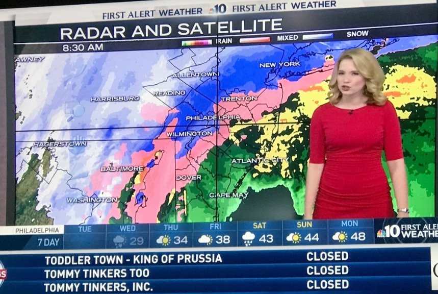
OK so you may have AWOKEN this morning to substantially less snow than was expected. Perhaps you weren’t expecting much at all if you’re in the city or south and east of it. But me, I live just above Doylestown and was firmly in the 15+ and ALL SNOW category in virtually every forecast. At around 5:15 a.m., I awoke to the rat-a-tat-tat of sleet pellets bombarding the window (and also a stirring child and a screaming migraine). I took the dog out three hours later– still sleet. The ice pellets are sitting atop a bed of 2-3 inches of snow. Meanwhile, I’m flipping back and forth between NBC 10 and Action News like a madman wondering where TF my white is. Both stations’ radars are flashing snow for all points north of the PA Turnpike. Not even close, holmes! THE RADARS ARE WRONG!
What gives?
Your new term of the day is DUAL-POL RADAR. Ex-National Weather Service man Gary Szatkowski has already pivoted to using it in his Twitter forecasts, and Adam Joseph has dabbled as well:
DUAL POL RADAR
Showing the correlation coefficient and where mixing of sleet and rain is taking place far south. pic.twitter.com/kfnexbhXtv— Adam Joseph (@6abcadamjoseph) March 14, 2017
Unlike conventional radar, which sends a single (horizontal) pulse into the storm, dual-pol sends, you guessed it, two– one horizontal, one vertical. This allows the radar to get a 2-D view of precipitation and a better understanding of its size and shape. Natch, it helps with identifying rain, sleet, snow and assorted flight birds. This is the radar you should be using. There’s a good explainer about it here. Only seasoned meteorologists can interpret the type of precipitation, but it seems the areas of mixing, which most of the Philly area is in now, is easy to spot.
Sweet, how do I get it?
Lots of people have recommended RadarScope. It’s $9.99 in the app store, and since I’m a psycho, I bought it without flinching.
Why don’t the TV stations use it?
I went straight to the source and asked Szatkowski, who, as I learned from SOURCES yesterday, isn’t particularly well-liked in TV meteorological circles. He offered the following:
Good question. It can be difficult to interpret, and I haven't seen a visually appealing version. Looks matter for TV.
— Gary Szatkowski (@GarySzatkowski) March 14, 2017
Noted. But I’d think it would be fairly easy to, graphically, change the simplified on-screen radars to better depict what dual-pol shows.
What does it show?
As I write this, at 8:33 a.m., it shows the rain-snow mix (green area) moving southward as the change over to ALL SNOW begins in upper Montco and Bucks and the cold air from the north moves toward the city:
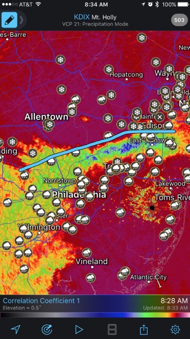
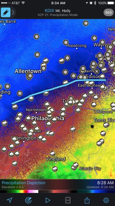
That app also offers precipitation depiction, which is similar to what the TV stations show (with all its problems), but even that seems more accurate than what you’re seeing on TV, and it was indeed spot-on for where I live, where A FIERCE FIGHT TO THE DEATH is currently taking place between sleet and snow, with sleet getting the upper hand with its more advanced pellet-to-pellet combat technique:
So the city will still get walloped with snow?
Not so fast, my friend:
Doubtful I-95 near Philly and points S & E are gonna make it even after a change to snow. From about Philly and 25 miles NW might not either
— Bobby Martrich | EPAWA (@epawawx) March 14, 2017
Gah!
NBC 10 has already lowered their snow fall estimates significantly, down to 8-12 in the adjecent northern and western suburbs, to 4-8 in and around the city, and less farther south. Though, as you can see, the indie folks seem to be predicting even less accumulation.
What happened?
The warm air from the south hung around a bit longer and a bit farther north than expected (as it does IN FUCKING MARCH!), taking that rain-snow line with it. The cold air from the north is beginning to dive down into the storm like a frat boy into a stripper’s tits (too much?), and hence the changeover back to snow happening in some areas.
What’s the call, Kyle?
Oh, sure, you want me to forecast it now? WITH PLEASURE:
The counties above Montco and Bucks I don’t understand: 12-18 inches
Doylestown: 12 inches
King of Prussia: 10 inches
Joel Embiid: A solid 9 inches
West Chester: 8 inches
Philly: 6
Delco: About three soft pretzels stacked on top of each other, give or take the mustard
South Jersey: Less than that.
Kyle Cam?
– Live "Kyle Cam" during a blizzard?.. Sign me the fuck up.. I'd watch the news for that segment..
— Hesi*Pull-up*Adio #BLM #ZFG (@AdioBRoyster) March 14, 2017
You don’t want Kyle Cam right now.

Kyle Scott is the founder and editor of CrossingBroad.com. He has written for CBS Philly and Philly Voice, and been a panelist or contributor on NBC Sports Philly, FOX 29 and SNY TV, as well as a recurring guest on 97.5 The Fanatic, 94 WIP, 106.7 The Fan and other stations. He has more than 10 years experience running digital media properties and in online advertising and marketing.