Ad Disclosure
STORMCAST 2016: Probable Annihilation
By Kyle Scott
Published:

The local news media has been needlessly hyping and sensationalizing the impending winter storm for days now, but I see no reason to panic because OH MY GOD GET ME MY MILK AND BREAD LEST I EAT MY OWN ARM WHILST BURROWED INSIDE MY TAUNTAUN.
Ah yes, the forecasts, models, maps, Euros, mesoscales, spaghetti plots, linguine charts, cappelletti bars, and fusilli funnels are out, and they’re all saying the same thing: you are going to die.
It seems that Philly has sidestepped destruction in the past few major storms, either due to the placement of the famed rain-snow line – the boundaries of which are typically and conveniently defined by 95 – or the path of the storm. Last year, WINTER STORM LINUS dumped only moderate snow on the area as the RS Line continually pushed north, while in the fall HURRICANE JOAQUIN completely missed us, as its cone of uncertainty continually went farther east.
This time around, it’s all about the path, and forecasters, both those who look good on TV and those behind the curtain who use a Marla Hooch-like Twitter avatar because their faces are stained by the glow of high-end weather modeling computers, are consistently in agreement that it will take the storm over D.C. and then up the I-95 corridor to North Jersey. Meet Jonas:
Brace yourself winter storm Jonas is coming pic.twitter.com/PeYcBDiXQU
— weezer (@Weezer) January 20, 2016
Snowfall projections have been relatively consistent among the models and have led to the National Weather Service issuing the following forecast:
GEW!
A blizzard watch has also been issued for the Philly area:
Green = Blizzard Watch, Blue = Winter Storm Watch pic.twitter.com/PFU1bvPSEE
— Kate Bilo CBS3 (@katebilo) January 21, 2016
Snow. Wind. Death. SWD for the entire viewing area up to the GTL crowd in NJ.
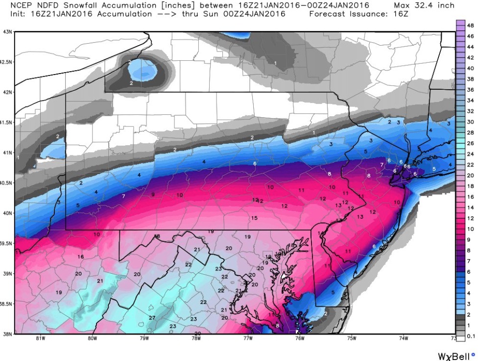
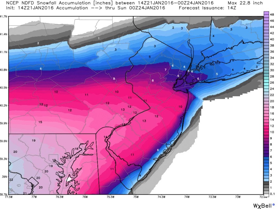
Here’s the thing, though, because there’s always a thing: it’s all about GRADIENT. This storm has an extreme GRADIENT (know that word, love it, coddle it), which means that snowfall amounts can vary wildly in distances as little as 20 miles or so. NJ.com’s weather guy called it BONKERS:
https://twitter.com/SStirling/status/690202097837543424
Just for illustration purposes, looks how tight this gradient is. Literally 0" to 15" in 30 miles. pic.twitter.com/TK1IVmLBkF
— Ed Vallee (@EdValleeWx) January 21, 2016
As of current models, which have been fairly consistent over the last 24 hours, snowfall amounts in the far northern and western suburbs can range from close to 20 inches to as little as 4-6. Earlier in the week, this gradient set up much closer to Philadelphia, which meant that areas south of the city – say, Glen Mills – could’ve been hit by a big boomer, while where I’m at in Horsham could’ve seen just a few inches. The models are now predicting a more northern track, which means pretty much the entire Philadelphia area and its immediate counties will get a lot of snow, likely 10+ inches. All local outlets and meteorologists are in agreement on this.
But, forecasters are quick to point out that, because of the sharp gradient, even just a 20-mile shift in track can change the forecast wildly. Note that one model – the GFS – has the Philly area at closer to 12-20 with just a slightly more northern track. Meanwhile, while the Jersey Shore might not get quite as much snow, it’s going to get absolutely pounded by a storm surge, and Cecily Tynan thinks it could be historically, Hurricane Sandy bad, writing on her Facebook page:
Before snow-lovers celebrate, consider the impact of a quickly developing nor’easter crawling up the coast: the shore will get battered. We’re talking wind gusts more than 60mph. major coastal flooding and beach erosion. This could be one of the top five storms on record for coastal flooding.
And:
I really want to stress even more that this is not all about snow: this storm is going to batter the New Jersey and Delaware coasts. The storm surge in Atlantic City on south could rival what happened during Sandy. So, please take the storm seriously.
In my few years of STORMCASTING, this is one of the few times where virtually all models and forecasters are in agreement that we’ll get hit hard. The last few storms have seen wild discrepancies in track and the RS Line. Not so for this one. But again, since the gradient is so sharp, even just a slight shift can drastically change snowfall amounts. So with the storm still 24+ hours away – it will likely start snowing late in the day on Friday and continue through the day Saturday, maybe even into Sunday – keep an eye out for potential changes in track. Godspeed.
Kyle Scott is the founder and editor of CrossingBroad.com. He has written for CBS Philly and Philly Voice, and been a panelist or contributor on NBC Sports Philly, FOX 29 and SNY TV, as well as a recurring guest on 97.5 The Fanatic, 94 WIP, 106.7 The Fan and other stations. He has more than 10 years experience running digital media properties and in online advertising and marketing.
