Ad Disclosure
STORMCAST 2017: Thick Wet Blast
By Kyle Scott
Published:

How big? About six inches.
That’s what she said.
That’s what they all said!
The spaghetti plots, tangerine maps, lemon radars and looney models are out and they spell our doom. Snow fall totals have gone up overnight and much of the REGION will be in a WINTER STORM WARNING early tomorrow, a sure sign of your impending demise. Godspeed.
How much snow?
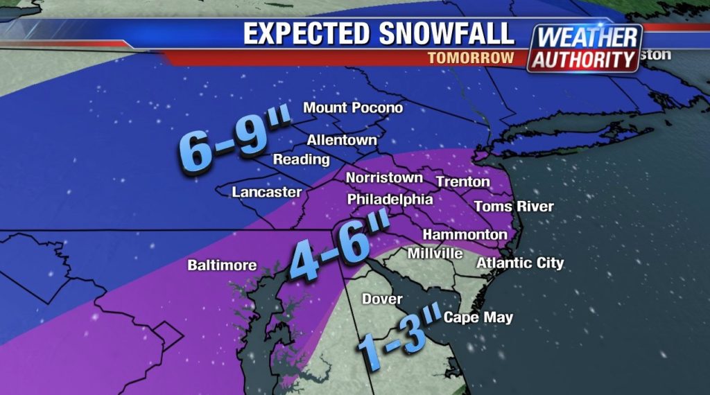
Most forecasts are in agreement that most of the Philly area will get a minimum of 4-6 inches, and then more further north and west, perhaps as much as 10 inches in Upper Bucks (hello!) and whatever counties are above it on the way to Allentown. Snow will be HEAVY at times. I’m talking hold your loved ones close and your gonads closer heavy. Up to two inches per hour during the height of the storm, the morning rush.
There will, however, be a strong GRADIENT on the southern tip (just the tip!) of the storm, and snow fall amounts will decrease sharply in South Jersey, ranging from upwards of six inches near the city down to about one inch in Cape May.
How much time do I have to save myself?
Not much. A cold air blast from the north will be diving down like Steph Curry at the faintest whiff of contact and it will meet up with moisture from the west, convening in the early morning hours and starting as rain for much of the area but as snow in the northern and western suburbs and then switching to all snow by the morning rush, WHEN THE PRECIPITATION WILL BE HEAVIEST!
This storm…
When will it end?
Like it matters. But in case your cat or something survives, he or she can begin to claw their way out around mid-day once the snow moves out. Temperatures will remain around freezing for much of the day and drop into the teens tomorrow night, refreezing any melted snow and slush and finishing off the small portion of humanity that made it through the initial snow fall.
How heavy will the snow be?
BACK-BREAKING! Perhaps thanks to the warm 60-ish temperatures today (I’m just making this up but it sounds good), there will be a lot of moisture in the air and make this a thick, wet, heavy snow. You shouldn’t try to shovel it if you’re at all weak or, honestly… just don’t shovel at all. Stay inside. It’ll melt… eventually.
How much death and destruction?
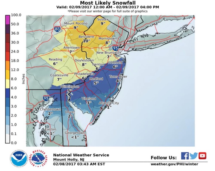
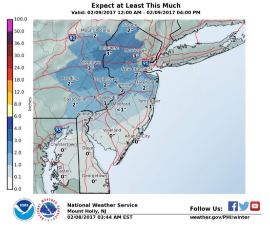
Good thing you asked! Thankfully the National Weather Service out of Mount Holly, headed up by our man Gary Szatkowski, puts out best- and worst-case scenarios in its briefing. Here is the dud version:
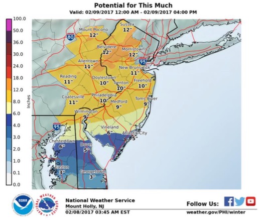
And here’s the EXTINCTION version:
Snow fall amounts will likely be somewhere in between.
Can it be worse?
Oh yeah. The hyper intense NY NJ weather guy (@nynjpaweather) says there could be MESOSCALING in Central New Jersey and New York, leading to high snow fall amounts and sinking air to the north. I don’t know what that means, but it sounds impressive. So if you’re in North Jersey… um, do whatever it is you enjoy doing because this will probably be your last chance to dance.
Will Sheena Parveen come back and hold me?
Sadly, no. She’s in Washington and hates you now:
It's all about #PayIt4ward next week! We're starting early with a surprise for some really deserving people…stay tuned! @nbcwashington pic.twitter.com/CWUvjY6pNF
— Sheena Parveen (@SheenaParveen) February 8, 2017
Anything else I need to know?
It’s never a bad time to do lunges… even though these are squats:
Lunges before dawn?! Check out how @VaiSikahema & @TracyDavidson stay in shape: https://t.co/QaQNDC800i #NBC10Mornings pic.twitter.com/eZxVeVzSi8
— NBC10 Philadelphia (@NBCPhiladelphia) February 8, 2017
Shut it down. Stay safe.
Kyle Scott is the founder and editor of CrossingBroad.com. He has written for CBS Philly and Philly Voice, and been a panelist or contributor on NBC Sports Philly, FOX 29 and SNY TV, as well as a recurring guest on 97.5 The Fanatic, 94 WIP, 106.7 The Fan and other stations. He has more than 10 years experience running digital media properties and in online advertising and marketing.


