
Ad Disclosure
I’ve Been Following this Twitter Thread Asking Where the Philly Suburbs Turn into the Exurbs (UPDATED)
Published:
I’ve been monitoring this post from Devo on X:
Hmm… yes. This is a good question.
Kneejerk response, I’d say that Philly’s Pennsylvania suburbs transform into the exurbs at the end of the Regional Rail lines. So anything north and west of Doylestown, Chalfont, and Lansdale, for starters. Looking at Lower Bucks, I think you’d draw the line right around the Richboro/Newtown area, like Almshouse Road or maybe Swamp Road. Then, on the western side, you’d say anything west of Thorndale, so Coatesville and Marsh Creek using 322 and West Chester as a reference point, more or less. If you go a little further south you can run the border going diagonally from Garnet Valley:
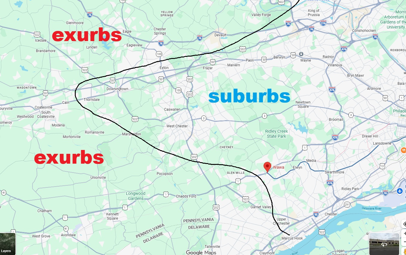
Is that reasonable? I think you have to bend the line around that Exton/Downingtown corridor because people commute into the city from there. But you go further north and you get into that portion of Chester County between Route 100 and Phoenixville and that feels like exurbs to me. Everything is a lot more spread out and the population isn’t nearly as dense.
The one thing that screws up the Regional Rail line of thinking is middle Montco. There’s no train line going up past Norristown, but there are parts of the 422 corridor like Oaks and Audubon that are definitely suburban. Phoenixville is right over the county line, but Phoenixville is a Philadelphia suburb. I don’t think you truly flip over to bumble-ish territory until you get up beyond Limerick and Schwenksville and drive Route 73 or Swamp Pike and touch the edges of the Perk Valley, Boyertown, and Upper Perk school districts. Then you’re close to the Berks County line and can get to Reading faster than Philly.
If I had to draw an arbitrary map, it would look like this for Montco:
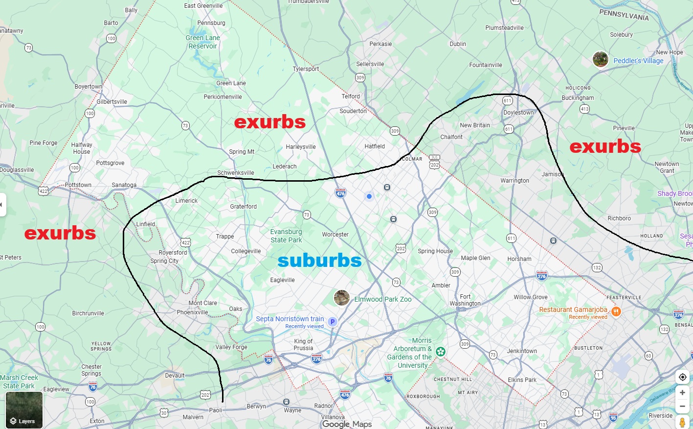
What say you? There are some outlier towns on here. I think Trappe and Royersford are hard to place. Souderton and Harleysville I don’t think are Philly suburbs. And even though the train runs up to Doylestown, that area around Warrington and Jamison is pretty spread out. Maybe we can crowdsource and make some rulings here.
Good post from Devo.
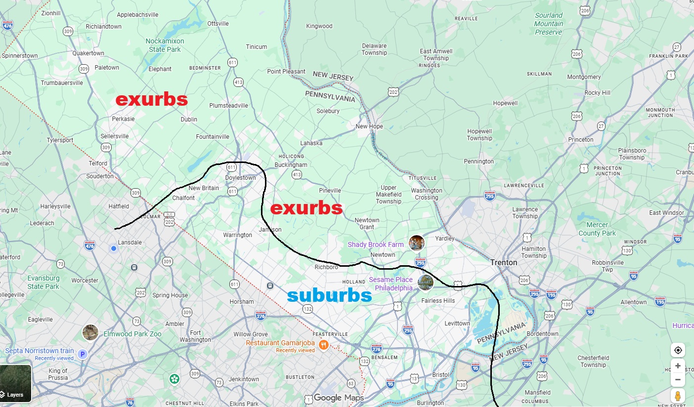
EDIT – I want to make a map for Bucks County. This one was tougher, but I think I’d do it like this, though that Sesame Place area kind of messed me up. I think the line would go along Route 1 there because I just don’t think you can say Yardley is a Philly suburb. But I could be wrong:
UPDATE 6/15 – Here are some bullet point notes after combing through the initial feedback:
- Lots of chatter about where to draw the Bucks County line. Some people argued for making 295 the border, which includes Yardley are a Philadelphia suburb. Others said it should be pushed up to the 413 line near Buckingham, which would essentially separate the Jamison/Warrington area from New Hope and Upper Makefield.
- A few people argued for Washington’s Crossing, but that felt like it was based on historical significance only.
- Others said the Montco line is too low, and should be pushed above Hatfield, Souderton, and Telford. I could possibly accept that if you’re using Route 113 as the border.
- Some of the Delco/Chesco people said 202 should be the line, which would exclude West Chester from the suburbs, and cut off the Paoli/Thorndale line.
- I disagree with people who said that every county touching Philadelphia proper is “the suburbs.” Bucks County touches Philadelphia proper but you up past Doylestown into the Palisades School District and you may as well be in another country. Same for the upper corner of Montco, which has East Greenville and Pennsburg. You’re really in the shadow of Allentown up there.
- RE: the area between Exton and Phoenixville, someone said this on X – “The line at marsh creek is correct. But Eagle / Chester springs are seeing a ton of development so you can probably include that area of 113 and 100. 113 between Lionville and Phoenixville is definitely more exburbs“

Kevin has been writing about Philadelphia sports since 2009. He spent seven years in the CBS 3 sports department and started with the Union during the team's 2010 inaugural season. He went to the academic powerhouses of Boyertown High School and West Virginia University. email - k.kinkead@sportradar.com