Ad Disclosure
STORMCAST 2016: Probably Not Stronger Than The Storm
By Kyle Scott
Published:

Well, it’s been a good run since Sandy, New Jersey.
In case you haven’t noticed, overnight the forecast for the Jersey Shore for Labor Day Weekend and into next week turned to shit. The consensus? Get on the ark and start procreating lest there be no more Snookis and snobby assholes from Stone Harbor (leave the dinosaurs behind).
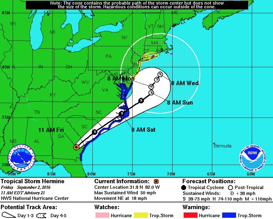
Hermine is now a tropical storm over the college football states, but once it re-enters the Atlantic on Saturday, it may re-intensify into a hurricane and then linger off the Delaware and New Jersey coasts until, oh, you know, MAYBE NEXT FUCKING FRIDAY:
Some GEFS members have #Hermine hanging off Northeast coast until 9/9(!) Would be complete devastation for NJ Shore. pic.twitter.com/SNLdFUhUM6
— Ed Vallee (@EdValleeWx) September 2, 2016
What does this mean for your holiday weekend plans? It means STAY HOME, YOU MORON. Our man Gary Szatkowski and other meteorologists too nerdy to bother with the TV thing predict that the Jersey Shore could suffer near-record level flooding Sunday regardless of the track of the storm:
06Z ETSurge guidance is in. Still flagging about a 4' storm surge this weekend. If that occurs at time of high tide, major coastal flooding!
— Gary Szatkowski (@GarySzatkowski) September 2, 2016
Now approaching a 20% probability of sustained 50 knot (58 mph) winds along the Jersey Shore. Stuffs gonna break. pic.twitter.com/b6thPguxKM
— Gary Szatkowski (@GarySzatkowski) September 2, 2016
Today is the #Hermine prep day for any storm preparation activities down at the Atlantic Coast. Winds and seas build on Saturday.
— Gary Szatkowski (@GarySzatkowski) September 2, 2016
Models currently forecast a 4 foot surge. That would imply top 3 event. IF that surge verifies, then major flooding with possible record.
— Meteorologist Dan Skeldon (@DanSkeldonWFMZ) September 2, 2016
Latest tidal flooding forecast for Atlantic City: Major flooding Sunday night. If forecast verifies, a Top 3 event. pic.twitter.com/xp2eWpdgMU
— Meteorologist Dan Skeldon (@DanSkeldonWFMZ) September 2, 2016
On the mainland, it will be breezy/wet. But by far brunt of this storm will be on barrier islands, beaches, and bays. Extended battering.
— Meteorologist Dan Skeldon (@DanSkeldonWFMZ) September 2, 2016
https://twitter.com/RyanMaue/status/771727600716767232
Very concerning tidal guidance has not backed off at all in AC since last night. @nynjpaweather @mattlanza pic.twitter.com/aaFib8hF9F
— StormForce_1 🍊 (@StormForce_1) September 2, 2016
Extended Battering– like a week at Brett Myers’ house.
Right now, the forecast is for heavy rain on Sunday, maybe as early as Saturday night, but that could vary wildly depending on a slight shift in the track. It will likely be very, very windy, with things picking up throughout the day Saturday. What is not up for debate, however, is the fact that this thing looks like it will park itself off the Jersey Coast like pile of trash floating in the surf off Ventnor and BATTER the beaches for several days. The Sunday night high tide could be a – how could we put this? – BIG FUCKING PROBLEM:
Atlantic City tide level records:
1) December 1992 Nor'easter: 9.0ft
2) Hurricane Sandy: 8.8ft
Sunday night tide 'forecast' in ballpark.— Meteorologist Dan Skeldon (@DanSkeldonWFMZ) September 2, 2016
Is this going to be as bad as Sandy? No, not at all. But it could be a top 5 coastal flooding event.
Am I going to die? It depends. Probably not if you stay away from the ocean. If you go near the beast, then yeah, probably.
What does Adam Joseph say? I’m not 100% sure because I was struck by how damn good looking he is after a run. But see if you can figure it out:
What does John Bolaris say? You’re probably going to die:
Good luck out there. Stay strong, but not stronger than the storm. No one is stronger than the storm… except for Adam Joseph after a run.
Kyle Scott is the founder and editor of CrossingBroad.com. He has written for CBS Philly and Philly Voice, and been a panelist or contributor on NBC Sports Philly, FOX 29 and SNY TV, as well as a recurring guest on 97.5 The Fanatic, 94 WIP, 106.7 The Fan and other stations. He has more than 10 years experience running digital media properties and in online advertising and marketing.
